Erosion of the Island
Erosion
Very strong winds are common in Vestmannaeyjar (Westman Islands) area, and shore erosion by oceanic waves is therefore substantial. For example, in an extreme storm on January 8 and 9, 1990, the average wave height reached 14 m southeast of Surtsey, which means that the highest waves were approximately 20 m high. Marine erosion is therefore tremendous in Surtsey. Even as the eruption was occurring, the coast of the island was continuously changing. Since 1967 the surf has cut away large parts of the island, although the erosion rate has slowed down considerably. In the first few years, 3-20 hectares of land disappeared annually, but in recent years an average of approximately 1 hectare of land has been swallowed by the sea each year.
Erosion of the Island
There are two factors that have rescued Surtsey from disappearing. The first is the lava that flowed in 1964-1965 and in 1966-1967. The second factor is the consolidation of tephra into palagonite tuff. The lava has protected the loose tephra in the south and east, while in the north the tephra has been protected by a narrow peninsula. To the west it was unprotected, which led to significant erosion until the hard core of the palagonite tuff was reached. The western part of Surtsey now consists of 120 m high palagonite cliffs.
The lava has also been eroded very rapidly by the sea. Close observation reveals that the lava is very cracked and intermediate scoriaceous layers diminish the resistance. The southwestern part of the lava has eroded the most. In that area of the island, a stretch of land up to 650 m wide has broken down and up to 75 m high sea cliffs have been formed.
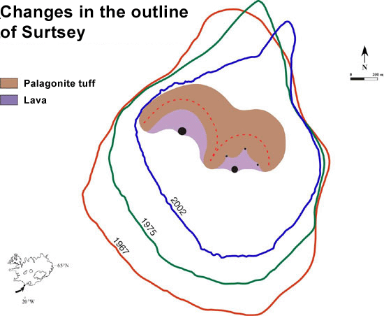
As was mentioned earlier, Surtsey measured 2.7 km² in total area by the end of the eruption, but as of 1975 its size had deacreased to 2.0 km². By 2002 Surtsey had decreased in size to 1.4 km², having shrunk to 52% of its maximum size in 1967
Wind erosion has also been considerable in Surtsey, especially erosion of the tephra during the first few years. At this time, a huge cloud of tephra dust could often be seen reaching far out to sea from the island. Winds have also eroded the palagonite tuff since its formation began. This erosion has not been accurately measured, but it has been estimated that 2-10 m have eroded off the tephra and palagonite tuff in various parts of the eastern crater.

On the sites where the islands Syrtlingur and Jólnir were once found, there are now only submarine hills. As was mentioned earlier, a peak called Surtla was also formed on the sea floor to the northeast of Surtsey. These submarine elevations have decreased in height at a steady rate due to erosion by sea currents. Syrtlingur disappeared in October 1965, and the present depth on that spot is about 34 m. Jólnir disappeared in October 1966, and the depth in that part of the ocean is now 39 m. On Surtla the shallowest spot was measured at 23 m in February 1964, but currently it is at least 47 m. These data on the marine erosion in Surtsey are very unique, as there are no comparable measurements from volcanic islands anywhere else in the world.
An effort has been made to predict the progression of marine erosion in Surtsey based on data on the island’s reduction in size over the years from 1967 to 2002. Theoretical models indicate that after 160 years only the core of the palagonite tuff will be left. Surtsey will then be surrounded by steep palagonite tuff cliffs that will slow down further erosion to a great extent. The palagonite tuff in Surtsey is very dense with few fissures, similar to the outer Vestmannaeyjar. In the future, Surtsey will most likely resemble the island Bjarnarey, which is approximately 5000-6000 years old.